Africa’s New Map? AU Pushes for True Representation of the Continent
Africa’s New Map: Why the Continent Wants Change
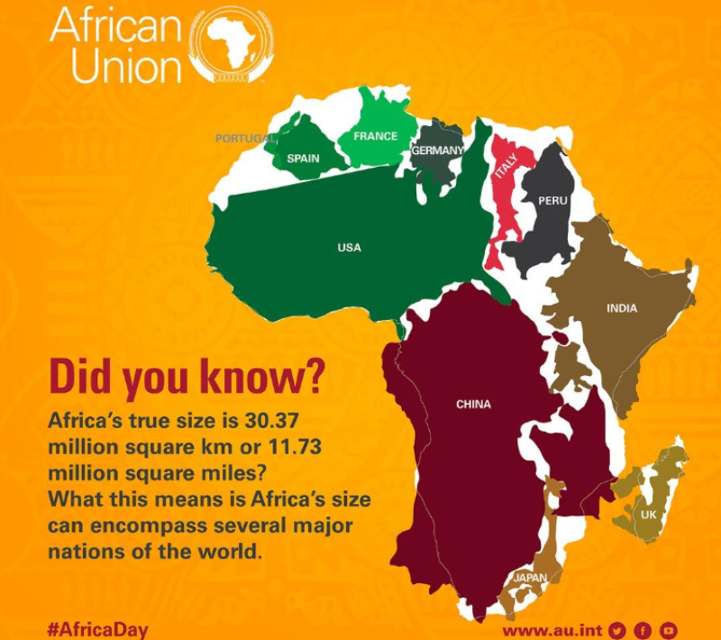
The African Union is pushing to correct the world map in a new campaign. The popular Mercator map projection, created over 500 years ago, distorts the real sizes of countries and continents. On this map, Africa looks almost the same size as China or the United States, but in reality, Africa is much larger. The AU insists the Mercator map is outdated and proposes the Equal Earth projection for schools and global institutions. This will help students and the world see Africa’s true size and importance.
The change is not just about geography, it is also about identity and awareness. By showing Africa’s real size on maps, the AU hopes to build culture, correct misconceptions, and give the world a better understanding of the continent’s scale, power, and potential.
Why the AU Supports the Equal Earth Map Projection
Fara Ndiaye, co-founder of Speak Up Africa, said the Mercator map affects Africans’ identity and pride, especially children who see it early in school.
“When students believe the projected image on the map is the actual size of Africa compared to others, which is far from the truth, it hurts their confidence. We are actively working on promoting a curriculum where the Equal Earth projection will be the main standard across all African classrooms.”
Ndiaye explained.
The Equal Earth projection, created in 2018 by Tom Patterson, Bojan Šavrič, and Bernhard Jenny, is a modern equal-area world map that shows the true size of continents. With the African Union now backing it, the campaign has gained new attention. For many years, Africans were unaware of how distorted the Mercator map was, but now the message is spreading. In reality, Africa is about three times the size of the United States, with a total land area of about 30.3 million square kilometers (11.7 million square miles) compared to the United States’ 9.8 million square kilometers.
Debate Over Africa’s True Size and the Mercator Map
Africa is large enough to fit Japan, China, India, the United States, and Europe combined within its land mass, and there would still be space left.
“The current size of the map of Africa is wrong. It is the world’s longest misinformation campaign, and it just has to stop.”
~ Moky Makura, Executive Director of Africa No Filter.
While the issue of the Mercator map and Africa’s size has gained attention, it has not been well-received by everyone. Some citizens argue that the size of Africa on the map is the least of their problems, insisting that the African Union should focus on more urgent issues that affect the daily lives and well-being of Africans.
Others, however, believe that correcting the map is important for teaching accurate geography and restoring pride in Africa’s true size. In the coming years, we may begin to see new map projections displayed in classrooms, public spaces, and tourist sites, finally showing Africa in all its glory.

Conclusion
Africa’s fight for a new map is more than a debate about geography; it is about truth, pride, and identity. By replacing the outdated Mercator map with the Equal Earth projection, the African Union and its partners hope to correct centuries of misinformation and give the world a clearer picture of Africa’s true size and importance.
Will the change be embraced quickly? Or will it face some resistance? Nevertheless, one thing is clear: showing Africa as it really is will reshape how the continent is seen, taught, and valued across the globe.